Looking for some context as to what this is post is about? Check out Part 1 by clicking here.
Success is not final
Failure is not fatal
It is the courage to continue that counts
“You are stronger and braver than you think you are”
These two messages were swirling in my head for the past three weeks as I pushed myself through 222 miles of the most rugged terrain you will find in the United States east of the Rocky Mountains. These two messages were texts of encouragement that I received from my father and my sister-in-law while I was dealing with some particularly strong moments of self-doubt in the town of Gorham, New Hampshire in early August. While I must be clear and stress that I’ve received hundreds of messages of support/encouragement from my wife, my family, and friends…and while I ABSOLUTELY STRESS I am incredibly humbled by and grateful for ALL of your amazing support…these two messages possibly stuck with me the most. They rang in my head over and over again in a three-week span as I pushed on from the town of Rangely, Maine (where we left off at the end of Part 1) and ultimately reached where I am today…the town of Hanover, New Hampshire, where I’m currently sitting in a library typing this up before heading out to get a whole pizza and some beer for lunch and then continuing on across the Connecticut River into Norwich…and the state of Vermont 🙂
“Success is not final
Failure is not fatal
It is the courage to continue that counts”
…DAMN RIGHT, DAD
“You are stronger and braver than you think you are”
…YOU KNOW WHAT, DAWN? YOU’RE GODDAMN RIGHT.
So, with that being said, and with my stomach asking for another impossibly-sized helping of calories, let’s get cracking and recount what exactly went down over the last three weeks. Let’s recount my battle with the mighty White Mountains of southern Maine and northern New Hampshire…
Day 17–July 27th, 2019
So, you might remember the first part of this day since this is the day I sat in the library and killed about 4 hours writing my first blog post until I almost passed out from hunger, but figure it was such a nice day off that it was a day worth repeating. For starters, I was staying at the Hiker Hut Hostel just off the AT and just outside of the town of Rangely. Steve is the name of the guy who runs the place and he has lived a large chunk of his life in India. All of the proceeds from this Hostel go towards helping disadvantaged children in India go to school and enjoy amenities similar to what we’re lucky enough to experience in America. It was very humbling and wonderful thing to see people doing things like this. So far, if this trail has taught me anything, it’s that human beings are inherently GOOD and when it really boils down to it, we’re trying to help each other out as we all go through the ups and downs of life. Don’t you dare tell me otherwise. After a nice breakfast at the Hostel, we all rode into town and arrived in the middle of a town festival. Can’t go wrong with a start like that. As the day went, it genuinely involved eating, blog writing, resupplying, eating some more, and hanging out with fellow thru-hikers. Ren, Grey, Sparks, Amazing, Speedy, Gonzalez, Sauce, and the Bricks were all in town today and we all caught up in some way or another. Again, everyone is just so nice and cool, and it really drives the point home that people are just inherently GOOD. As the day wore on, we saw more and more people crowding into town because Steve Miller (FRICKIN’ STEVE MILLER!) was in town to play a show. So, me and a few other hikers decided to avoid the rush and caught a ride back to the hostel to relax for the rest of the night. Sitting by a tiny river, sipping a beer and reading parts of “The Two Towers”…man, I could have a day like that every day and be a happy man
MILES COVERED: ZERO DAY!
TOTAL DISTANCE OF AT COVERED: 220.4 miles
Day 18–July 28th, 2019
So other than the fact that raccoon tore through the hostel at 2:15 in the morning and the caretaker (Tomb Raider) had her dog attack and chase off the raccoon, it was a pretty quiet night! Afer a quick breakfast, I was back on trail by 7:00. I relished the first 13.5 miles because it was a relatively flat and easy stretch of trail…probably the last flat and easy stretch I would face for a couple of weeks. I find that I like to hike alone during the day and that I really enjoy the company of people at shelters/campsites in the evening. Nevertheless, meeting really cool people during the day is inevitable…Soulshine, Beet Slices, and Motivating Factor (or M.F.), Old Moose, Switchback, Cricket, Salamander, and other NOBO’s too numerous to mention. Also met Lilian and David at an overlook while crossing Maine State Route 17. Finally, got some trail magic from Gregg and Geri in the form of a cooler full of water, soda, and snacks. All great highlights in the first half of the day. The second half of the day was my first true “escape.” As I was climbing up Bemis Mountain which has a series of three peaks, I was just over the first peak and starting halfway up the second one when the sky suddenly CRACKLED with thunder. Being under tree cover most of the time, I didn’t notice black clouds sweeping in from the west. But now, though…I was climbing above treeline and the clouds were getting way too close for comfort. Anyone who knows ANYTHING about me knows that I am a complete and total coward when it comes to thunderstorms. If there’s so much as a rumble of thunder, I tend to find a basement and crank up the TV and PlayStation as loud as possible to distract myself from what I’m sure is my impending doom. Now, I was stupidly above treeline on a mountain with thunder and lighting approaching quickly…and I was holding two metal trekking poles as well. You know when that little voice in your head goes “Oh S**T, oh S**T” and gets louder and louder the more you realize you’re in a predicament? Well, that’s what was happening to me. And so, I made a careful decision…RUN LIKE HELL! So for the next 30 minutes, I ran 3 miles across the exposed ridgeline as the clouds and lightning got closer and closer. There was a shelter just over the 2nd peak…just 3 miles ahead. I could make it before lightning finished me off, right? RIGHT?! OH S**T!!!! OH S**T!!!!!…It was not a fun experience, but long story short, I made it to the shelter and got inside about 10 minutes before the storm caught me, sweeping across the shelter with high wind, loud lightning, and pouring rain. For several minutes, I was sitting there in the shelter with three NOBO’s…Doc, Black Forest, and Lost Boy Scout…utterly petrified. Then, in a few minutes, as the rain continued, we were all laughing, telling stories, and cooking our dinners. I was doing something I never thought I could do. Survive a storm outside and actually have fun with it! Off to bed early that night…I had a new idea planned for the morning…
MILES COVERED: 17.7 miles
TOTAL DISTANCE OF AT COVERED: 238.1 miles
Day 19–July 29th, 2019
Has anyone ever tried night-hiking? Where you get up super early, hike just by the light of your headlamp, and try to bag as many miles as you can before the sun is up? Well, I finally decided to try it…and I don’t recommend it to anyone. Maybe it’s because my headlamp needed new batteries, or maybe it’s because I’m incapable of operating at 100% before 6 AM, but in either case, I got up at 3:30 and started hiking at 4:00 (making sure to quietly pack up and leave so as not to disturb my new NOBO friends). Immediately, I lost the trail and had to rely on Gaia on my phone to keep me from becoming MIA. After Gaia helped me find the trail, I repeated this process about 5 more times before finally just gritting my teeth and sitting down in the dark for 15 minutes to get my bearings. My mind immediately started thinking, “hey, do you think the Blair Witch is real?” and “weren’t there reports of alien abductions in Maine?”. Thanks, brain! Really appreciate the moral boost here. Finally, my fear of the Blair Witch overcame my annoyance of my head lamp being slightly dim and I started hiking again in the dark. This time, I tried going slower and more methodically and I found out I was actually able to follow the trail in the dark. Within a couple of hours, the sun had risen and I had already covered 8 miles of trail! Not too shabby. A little later in the morning, I ultimately reached a roadside crossing and caught a hitch from a sweet older lady named Ann into the town of Andover, where I got a room at the Human-Nature Hostel. There, I took the afternoon off to sit on a couch and have my monthly conversation with my personal life coach and friend, James Simpson of the Arizona Family Institute. I have to express my sincere thanks to him for the guidance he has given me over the last year of my life and how he has helped me build a better understanding of myself and my values. Having 3 weeks on the AT before I chatted with him made for a new list of items he and I could discuss, and without going into too much detail, he told me exactly what I needed to here. With that call done and my emotions slightly spent, I sought the comfort of fellow hikers, food, and a beer. Fortunately, the awesome Human-Nature Hostel provided all of that. Yukon (the owner) is one of the coolest dudes I’ve ever met, and fellow hikers T, Puff, Godzilla, and others helped provide the companionship I needed that night. Overall a great day.
MILES COVERED: 18.7 miles
TOTAL DISTANCE OF AT COVERED: 256.9 miles
Day 20–July 30th, 2019
As seems to be the case with the trail, there’s a ying and a yang. For every good day, there’s a bad day. Remember in Part 1 when I talked about my slog through the Chairbacks where I dealt with an unprecedented level of hatred and self-loathing and also wanted with every fiber of my being to quit the trail? Well…guess what? It happened again today. I knew the day was going to be a bad one because as soon as I woke up, I got hurt. You see, I’d been bandaging my feet with Leukotape to help prevent blisters and to help the backs of my ankles recover from the brutal beating they received in the 100-mile wilderness. After a couple of days of wearing the tape, I wanted to change it and replace with a fresh layer. Unfortunately, when I was removing the tape, I pulled too hard and took about half the skin off the bottom of my big toe on my left foot. Ouch. Cursing my poor decision, I wrapped about 4 layers of tape around the wound and forced myself to walk around on the cut and make sure I could still hike today. I could, but now I was in a bad mood with a bad mindset. The day itself hiking-wise started out well enough. I got back to the trail and started hiking around 8:30, but I always had one eye on the sky because of storms being in the forecast, and I was sweating like crazy from the heat and humidity that was very unusual for Maine. Ultimately, I made it up and over the VERY STEEP Baldpate Mountain, and then decided into Grafton Notch. And with that…I was now officially at the start of the White Mountains…the most impressive and most technically challenging mountain range to hike in all of the eastern United States. I talked in Part 1 about how the Whites are considered the most difficult section of the entire Appalachian Trail and how while I had a belief I could succeed, I was also very nervous about how much of a challenge it would be. Well…without hesitation, I headed out of Grafton Notch and started climbing up the first mountain in the Whites…Old Speck…and it KICKED. MY. ASS. Halfway up the mountain, there I was again, in the same position as I was during the Chairbacks…sitting on a rock, legs shaking, trekking poles strewn on the ground in front of me, and tears pouring down my cheeks as I thought about how much this sucked and how much I would rather be home with my wife and two dogs. To add insult to injury, thunder rumbled in the distance. But at least I had one thing I didn’t normally have…a cell signal. So I texted my wife and told her “this is so hard. this is SO HARD.”, angry and hot tears coming out of my eyes as I pounded those words out on my screen. But my wife, my wonderful amazing and loving wife, began to calmly and wonderfully reassure me that all the pain and anger and fear and shame and sadness I felt was temporary and that it was all of my own making. That it was stemming from me putting too much pressure on myself and that I was trying too hard to force myself down the trail rather than taking the time to just enjoy and experience the challenges the trail was giving me. Maybe I’m not putting it into the right words, but the bottom line is…she was my angel at that moment and she told me exactly what I needed to hear to keep going. As if the heavens were in sync with her, the clouds that had been gathering above the mountain started to part and the thunder went away. Slowly I stood up, and ONCE AGAIN, wiped away the tears (“I’m not gonna have any more tears left by the time I get to New Hampshire” I told myself with a little laugh), and continued climbing. It sucked. It really really sucked going up Old Speck. That mountain kicked my ass. BUT…I made it to the top, and by 5:30, with the clouds starting to gather again, I had made it down the other side and was safe and sound in the Old Speck Pond Shelter, chatting with the AMC Caretaker named Peter. He, too, told me exactly what I needed to hear and gave me the moral boost I needed. Again, people are proving to me they are inherently good and just want to help each other out. It’s amazing to see. Went to bed in the shelter as the thunder began to pick up. This time, I didn’t even care it was thundering. I was safe in a shelter and I had survived another day on this cursed and wonderful trail.
MILES COVERED: 14.9 miles
TOTAL DISTANCE OF AT COVERED: 271.8 miles
Day 21–July 31st, 2019
“I deserve to be happy.” Remember when I said that in my last blog? Well, I said it again today. More storms were in the forecast, and the terrain in front of me was the toughest terrain on the ENTIRE Appalachian Trail, including the famous Mahoosuc Notch. The Mahoosuc Notch is essentially a giant maze of boulders that the trail goes right through for just over a mile. It takes the average hiker almost 90 minutes to cover just this one mile of trail. For this reason, it’s called “the toughest mile of the Appalachian Trail.” For all these reasons, I decided that I was going to play the day by ear and only do what my gut told me. For starters, I packed up my stuff and then talked to Peter about the most recent weather report that he had been radioed. He let me know that the storms, which were supposed to start in the mid-morning, were now not starting until the late afternoon. Good news! As a result, I decided to start hiking and only planned to bag a few miles at most, then find shelter before the afternoon storms rolled in. The end result was a 5.1 mile day that took me across the Mahoosuc Arm (perhaps the most difficult descent on the entire AT), and then into the Mahoosuc Notch itself. And how was it? It was…MY FAVORITE SECTION OF TRAIL! I didn’t rush myself at all, so I strapped my trekking poles onto my pack and began to basically rock-climb across boulders all the way across the Notch. While I was going through, I felt like I was in an air-conditioned jungle gym! You see, the whole Notch is so well hidden from the warm summer air that even in late July, it’s as cool as a refrigerator and there’s still bits of snow and ice hidden under boulders! Plunging my hands into snow and ice in late July was a really cool experience, and I found I couldn’t stop smiling just one day after nearly quitting the trail on Old Speck. Amazing how quickly this trail makes your emotions turn one way or the other. I was having so much fun, that I didn’t realize how fast I was moving, and within a mere 55 minutes, I found myself on the other side of Mahoosuc Notch. MAN, that was fun. As a result, I decided to reward myself by doing just 2 more miles of trail and climbed up to the Full Goose Shelter, where I hung out all day chatting with hikers who passed by, eating a ton of leftover food in my pack, and relishing in the fact that tomorrow I would be entering a new state!!! In the evening, to my wonderful surprise, my friends the Bricks showed up to camp for the night. As thunder grumbled overhead, we laughed, told stories, shared food, and even smoked a little to celebrate the fact we had made it through the toughest mile of the entire AT and had made it through the entire state of Maine. Again, amazing how emotions can change in the span of a day out here.
MILES COVERED: 5.1 miles
TOTAL DISTANCE OF AT COVERED: 276.9 miles
Day 22–August 1st, 2019
I was frickin’ ready to be done with Maine. I’ve been in this state for too long and I’m ready to get to New Hampshire and attack these White Mountains full tilt. By 6:15, I was packed up and moving, I crushed two mountains in less than two hours, and by 8:30…I found myself standing in a place that seemed impossibly far away three weeks ago…the Maine and New Hampshire state line! I took a few pictures to celebrate my accomplishment, then pressed on. The town of Gorham was about 17 miles away and I wanted to get there that night. Certainly because I craved an actual bed, but the other thing was that Gorham had a MCDONALDS!!!! I hadn’t had fast food since this whole trip started, and I NEEDED it!!!!! With visions of Quarter Pounders and McNuggets dancing in my head, I reached Gorham by mid-afternoon and had banged out my largest single day on the entire AT at 21.4 miles! I settled into the Rattle River Hostel, which sat right on the AT and right at the entrance to the White Mountain National Forest, where most people say the White Mountains ACTUALLY begin (but clearly, those people haven’t climbed Old Speck). While I sadly couldn’t get my McDonald’s until tomorrow, I was nevertheless able to resupply at Wal-Mart (never have I been so happy to see a Wal-Mart) and I was able to meet a new cast of characters…Sweetgum, Cottonwood, Cheshire (an amazing girl who slipped and broke her leg in the Mahoosuc Notch, but is planning to be back on trail within 6 weeks…shout-out to you, Cheshire!), Pelican, and Serendipity, and more. You all rock. By 7:00, I was in bed and out like a light. I needed sleep…and the hardest mountains were now just outside the door…
MILES COVERED: 21.4 miles
TOTAL DISTANCE OF AT COVERED: 298.3 miles
Day 23–August 2nd, 2019
Of course, one can’t tackle the main part of the Whites without first getting a day off. But even in days off, it’s amazing just how much happens. Marc and Angie (remember Marc and Angie, the amazingly awesome trail angels from DAY 1 of my thru-hike?) stopped by the Rattle River Hostel in the morning and took me out for an amazing breakfast in town at Welsh’s Restaurant. And when we walked in, who else was there but Photon and Cool Runnings!!!!! I hadn’t seen them since Day 3 of my hike! After hugs and pictures, we all relished in the fact that the trail, even if for just a fleeting moment, had brought us all back together. I knew this was probably the last time I would see them since they are continuing to hike at an absolutely MONSTROUS pace compared to me, but to see them, along with Gandalf and M.O.M., it was a really cool and special moment. After that awesome meeting, Marc and Angie and I had breakfast and planned for how I should attack the Whites much like how a war general plans his conquest of enemy territory. Several cups of coffee and plates of eggs, meat, and waffles later, I felt like we had established a fool-proof plan that would result in total victory! With a happy stomach and a full resupply, Marc and Angie sent me back to the hostel for the rest of the day (Marc and Angie, if you are reading this, I again can’t stress to you enough how thankful I am for you guys. You’re so amazing and have been a great driving force since Day 1. My sincere thanks). The rest of the day is kind of a food-coma blur, to be honest. I remember meeting many more hikers, eating enough food to make an elephant say “uhh…that’s enough, dude”, and watching most of Stranger Things (the theme of which would play in my head for the next week). I decided that tomorrow, I would do what’s called a “slackpack” of the first 21 miles of the main section of the White Mountains…specifically, the Wildcat Range and the Carter-Moriah Range. No point in starting too easily, right?
MILES COVERED: ZERO DAY!
TOTAL DISTANCE OF AT COVERED: 298.3 miles
Day 24–August 3rd, 2019
For those of you who don’t know, a “slackpack” is when you leave your main pack behind and you only take a day’s supplies (for example…some food, some water, your water filter, your headlamp, and some emergency clothes) that are stuffed in a small backpack. That way, you’re carrying much less weight and you can go much faster and farther over more difficult terrain. The catch-22 is that you don’t have your tent or sleeping bag or anything like that, so you have to successfully complete the slackpack in a single day. I was attempting what was called the most-difficult single-day slackpack on the entire AT…a 21.1 mile hike across the entire Wildcat and Carter-Moriah Range of the White Mountains, which comprises about 7000 feet of elevation gain in that one stretch. However, I was confident I could do it. My legs were getting stronger every day, my feet were almost fully healed from the 100-mile wilderness of Maine (which now seemed ages ago), and the weather was FINALLY immaculate. Blue skies as far as the eye could see. I hopped on a shuttle at 7:30 and by 8:00, I was in Pinkham Notch and beginning my 21.1 mile hike back to the Hostel. As soon as I started hiking with just my small backpack, I couldn’t believe how much simpler it was to hike faster and scramble up rock climbs faster. A bag that weighs only 8 pounds is INCREDIBLY light compared to a pack that weighs 35 pounds. As a result, not only did I finish the hike in a single day, I had finished it by 5:30 PM. 9.5 hours…to go 21.1 miles across 2 mountain ranges. I’ve always dealt with issues of self-confidence as I’ve said countless times already on this blog, and I gotta tell you…when I can do things like this…man, I really do feel like I can do anything. It’s an AMAZING feeling. By 6:00, I was sitting on a couch in the Hostel, a pizza on the way, watching more TV with Kiwi and two other NOBO’s, and relishing in the fact that I could take another zero tomorrow before pressing on because I had accomplished in one day what a lot of other hikers do in two. When my body gets stronger, I think my mind does as well, and it’s nice. 🙂
MILES COVERED: 21.1 miles
TOTAL DISTANCE OF AT COVERED: 319.4 miles
Day 25–August 4th, 2019
Yes, it was another zero, and I had some friends ahead of me who were hiking faster and putting more distance between me and them, but who cares? We’re all out here to hike our own hike and have fun with it at the same time. There’s no right or wrong way to hike the AT other than the fact you just have to hike it. So as a result…another day of eating food, watching movies with fellow hikers (Space Jam for the first time in AGES!), and getting a shuttle into town again for a final resupply and helping of town food. On this final trip into town, I did something I never would have done before. I walked through a drive-thru at a Burger King. You see, the lobby was closed, right? And you know me…if I have a chance to get fast food…well, I’m GETTING FAST FOOD. So, with many confused drivers staring at me…and some even pointing and laughing…I stood in between two cars and patiently worked my way through the window where I calmly placed an order and they (with some confusion) actually filled it for me and sent me on my way. Normally, in these situations, I would be so self-conscious and embarrassed to be doing something like this, but this time, something happened. I didn’t care what people thought of me. If they wanted to laugh at me, fine. If they wanted to think I was some homeless guy with a dirty beard trying to pitifully get a meal, fine. I didn’t care. I was doing what I wanted and I was happy with it. And that’s good enough. Funny how sometimes it takes a 320-mile walk to understand things like this. As I got back to the hostel and ate with other hikers, we were all staring at the map and what was coming next. For SOBO’s like me, it was the greatest test since Mount Katahdin. It was the start of the Presidential Range of the White Mountains, which include several 5000+-foot peaks such as Jefferson, Madison, Adams, and oh yes, this little one called…MOUNT WASHINGTON. You may have heard of this place. It has the record for the highest recorded wind speed as well as the record for the coldest temperature in the USA. It’s the most rugged peak in America east of the Mississippi, and the section of trail I was hiking on tomorrow would take me right over it. I hope the weather was gonna be good…
MILES COVERED: ZERO DAY!
TOTAL DISTANCE OF AT COVERED: 319.4 miles
Day 26–August 5th, 2019
While part of me wants to regale you with tales of a great battle that took place between man and mountain, I’m sitting here typing this very relieved that I got a very peaceful, quiet, and WONDERFUL day as I trekked through the Presidential Range. Maybe the best day of weather I’ve gotten since I started this entire crazy trip. Also, the day got off to a great start due a section-hiker named Trout cooking omelettes for every hiker in the hostel. Thanks, Trout! Same as before, I got off the shuttle at 8:00 (this time with my full pack) and I hiked with a fellow SOBO named Drop-zee through the first several miles of the Presidentials, including the infamous 3,000 foot climb up the side of Mount Madison. This was a climb I had been fearing for weeks, but honestly, it wasn’t half as bad as a thought. Maybe my trail legs were finally in full force. After a quick break at the Madison Springs Hut (the AMC owns and operates a series of huts in the White Mountains where hikers can eat and…for a hefty fee…sleep), I continued on across three other summits (where I was also given a couple Tootsie-Pops by day hikers, which I then split with a NOBO named Bones), and then was finally at the approach that would take me over Mount Washington. At 4:00, with my legs shaking and myself gasping for air, I found myself standing at the 6,288-foot summit with clear skies and calm wind. What amazed me was how many people were on the summit who were looking at me like I was a caveman from another eon, and how these people looking at me all looked immaculate…men in fancy sweaters, women in high heels, kids in football jerseys…it all seemed so funny that there was such a contrast between us (remember that there’s an auto road and a train that go to the summit of Mount Washington). My favorite moment was when one lady incredulously looked at me and said “you WALKED up here?!?!?!” After a quick picture at the summit, and a quick bite to eat in the gift shop (why doesn’t EVERY mountain I climb have a gift shop?!), I headed down the other side of Washington and towards the Lake of the Clouds Hut, where I was able to get a morning work-for-stay so that I could stay for free and gorge on leftover food in exchange for doing about an hour of work around the hut. I can’t stress enough how amazing of a day this was. The views through the whole Presidential Range were amazing, topping many views I’ve seen in the western United States. New Hampshire’s White Mountains truly are an amazing place.
MILES COVERED: 15.0 miles
TOTAL DISTANCE OF AT COVERED: 334.4 miles
Day 27–August 6th, 2019
After a nice night sleeping on the floor in the dining room of the Lake of the Clouds Hut with other thru-hikers, I gorged on breakfast leftovers and then, with Mystery and Bad Advice Bug, did about an hour of chores. For an hour, I swept and cleaned all the bunk rooms and then stomped on the compost pile in the backyard. Not too bad in exchange for getting two huge meals and a place to sleep! By 9:00, I was on my down from Lake of the Clouds and heading towards Crawford Notch. It was steep, rocky, and slow-going under a hazy and hot summer sun, but by 2:45, I had reached the Notch and was trying to get a hitch down to a local general store and campground. For the first time all trip, I had real trouble getting a ride. But considering I had a wild beard, smelled like a barn (at best), had a large backpack, and was wielding two club-looking poles, I’m probably not seen by most people as a pleasant hitchhiker. Nevertheless, many people in the area understand the trail and how hikers always need rides, so eventually after about a mile and a half of road-walking, a nice man pulled over and told me to hop in. Minutes later, I was at a general store and campground waiting for my friends Sweetgum and Cottonwood (who were a few miles behind me on the trail) to successfully get a hitch as well. Sure enough, about an hour later, they pulled up and we were able to relax the rest of the day together, toasting our success in the Presidentials and realizing we were just under halfway through the Whites! That night, as we sat in our campsite around a picnic-table eating our dinners, we realized just how much we had become thru-hikers. Why? Because we realized we could calmly talk about pooping and feet while eating. Ah, the thru-hiker life.
MILES COVERED: 11.0 miles
TOTAL DISTANCE OF AT COVERED: 345.4 miles
Day 28–August 7th, 2019
“Be prepared to take extra zeros.” This was one of the best advice tips I had gotten before entering the Whites, and it rang true on this day. I decided to zero at the campground not because my legs were sore or because I needed a mental break, but because of the weather reports. Severe storms were forecast for the afternoon, and I wanted in no way, shape, or form to be on top of a mountain range when a storm, much less a severe storm, blew in. As a result, I sadly waved good-bye to Sweetgum and Cottonwood as they decided to at least get a few extra miles in before the storms hit, and I settled into a simple day of listening to podcasts and eating food and talking with other campers. Honestly, a simple day with not much to report, and surprisingly, I was happy about this.
MILES COVERED: ZERO DAY!
TOTAL DISTANCE OF AT COVERED: 345.4 miles
Day 29–August 8th, 2019
BOOM!!!!! Midnight strikes and with it, a bolt of lightning less than a mile away. I wake up in my tent with a start and put on my headphones to try and drown out the storm. For a while, it works. Then…the same thing happens again at 2:30. So it went all night. By 6:30, I found one corner of my tent was starting to leak because of the rain that had been relentlessly pounding it all night. “Great…gonna be another of those days again, isn’t it?” I thought to myself, “might as well get moving and deal with the suck.” So, I soon found myself packing up my gear and tent in the pouring rain and by 7:30, walking down the highway again back to the AT, trying to get a hitch. Once again, very little luck. However, one very nice man named Jonathan (who was in the area attempting to climb all 48 of New Hampshire’s 4000+-foot peaks) eventually pulled over and drove me back to the trailhead. Another day where storms were in the forecast for all afternoon, some of them possibly severe. But this time, I wasn’t going to sit bored in a campground all day again. I decided I would simply run across any section of trail above treeline and then at each shelter, reassess the situation, all the while doing an anti-storm dance. The result was a surprisingly good day. I had lunch at the Zealand Falls Hut by 10:30 and reached the Galehead Hut at 3:30 after bagging Mount Guyot and South Twin. I was able to even get an evening work-for-stay at Galehead and so I was once again able to feast on leftovers and sleep on the dining room floor in exchange for just 45 minutes of washing dishes (lots and LOTS of dishes) with NOBOs Sharkbait and Backtrack Chicken. During the day, I ran into Cottonwood and Sweetgum again (who were deciding to push on just past Galehead), Bop-It, Bushman, Skittles, and others. The clouds stayed iffy, but relatively calm all day. “Each day is whatever we choose to make it” I think to myself as I drift off to sleep on the dining room floor of the hut…
MILES COVERED: 14.7 miles
TOTAL DISTANCE OF AT COVERED: 360.1 miles
Day 30–August 9th, 2019
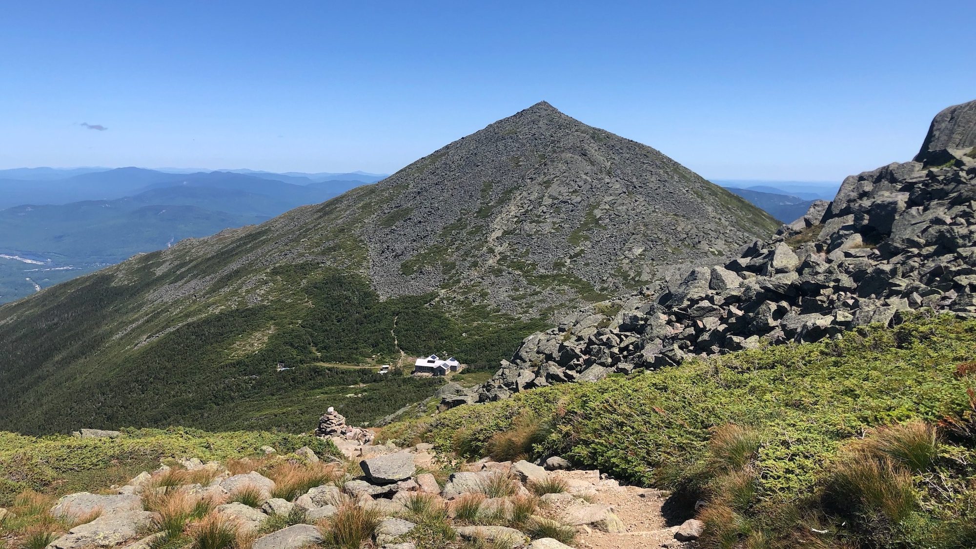
The previous night, I had been woken up by a loud crack of thunder. This morning, I was woken up by a loud WHOOOOOOOOOSH at 5:30 as a sudden wind and rain storm broke over the Galehead Hut. Such is life in the White Mountains of New Hampshire. The weather is extreme and you just have to go with it. So…I sat on my hands for about an hour, waited for the storm to pass, and then continued on my merry way, bidding adieu to my NOBO friends from the night before. Today was a day I had waited for since I had started my thru-hike: Franconia Ridge. It’s what many hikers say is the prettiest section of all of the White Mountains. I had day-hiked it with my wife back in 2015, and so far, I agreed with that statement. The problem is…you have to actually SEE what’s around you if you want to appreciate it, and by the time I had reached the top of Mount Lafayette, I hadn’t been able to see anything all frickin’ day because the section of the mountains I was in had been in the clouds all day. On top of that, going up Mount Garfield earlier in the morning, I had fallen sideways awkwardly and snapped one of my trekking poles clean in half. In anger, I hurled the short and broken end into the woods while yelling some…choice words. It took a few seconds for that anger to suddenly dissolve into shame…I had just broken the worst rule you can break on a thru-hike: I had littered. I had thrown a piece of metal deep into the woods and I had no clue where it went. I quickly found myself cursing my stupidity and beating myself up again for being such a loser, but this time, I didn’t spiral. This time, I stopped beating myself up, I turned to a tree (in retrospect, this seems much weirder…), put my hand on it, apologized, and promised for as long as I could, I would pick up any trash that I found on the trail to try and somewhat make up for my mistake. The woods seemed to reciprocate in kind because I then spent a lot of the next few miles picking up numerous food wrappers and even a ziplock bag filled with…possibly dirty toilet paper…and stuffing it in my trash bag. I guess I deserved it, though, and I’m still picking up anything I can find to try and make up for the error I made that day in anger. Anyways, I’ve been rambling. Back to Lafayette. I got on top of Lafayette and what should have been an amazing view was instead the amazing grey inside of a cloud. I was again thinking this was nature paying me back for my littering mistake, but then just as suddenly, the clouds parted, and I got the view that I had been dreaming of since I started the AT. For the next 4 miles, I walked across a ridgeline that practically made my jaw hit the ground from the sheer beauty of the views I had. “This.” I thought to myself, “this is why I’m out here.” After those 4 great miles, I began a long descent down to Franconia Notch. The Whites were now 3/4 of the way finished. It was great to be back in the Notch because Ashli and I had spent 3 weeks here last summer, so it was funny to see all the familiar restaurants, shops, and parks again. I grabbed a beer with a NOBO friend named Billy the Kid, I grabbed a replacement trekking pole, and got a room at the Notch Hostel. Ups and downs, ups and downs, both literally, and figuratively. That’s how the trail has been for days now.
MILES COVERED: 13.0 miles
TOTAL DISTANCE OF AT COVERED: 373.1 miles
Day 31–August 10th, 2019
Once again…I decided that it’s not worth climbing mountains in possibly severe weather. Thus, I decided to take another zero day at the Notch Hostel due to the possibility of severe storms in the forecast. Since the hostel was booked solid already since it was the weekend, I was moved to what the hostel called “The Cabin”, which was an old storage shed converted into a spare room for thru-hikers. Surprisingly, I absolutely loved the peace and quiet in there and actually hung out there for a few hours reading and relaxing. “I’m amazed how much I crave solitude now”, I thought to myself throughout the day, but I guess when you’re in the woods for a month, it only makes sense to feel more comfortable in a small group. However, as the afternoon wore on, I began seeking some companionship and I got it from fellow SOBO’s Anubis, Acid Jesus, Bunkhouse, and Bop-It, who happened to have arrived in town the day before. Small groups for short periods of time had become my desired companionship, and we happily chatted for a bit before each heading into town for food and booze. After a quick bite and a couple drinks, I found myself wanting to be back in my Cabin again, and so I headed back to the hostel just as the sky opened up and brought more wind and rain with it. Considering I had zeroed for this, I was actually kinda satisfied to see a storm hit. Never thought I’d feel that way. Again, trail changes your perspective over time. When I got back to the Hostel, I again gained an understanding of how the trail changes your perspective. The hostel was packed with a group of day-hikers and bikers from around New England, mostly baby boomers who were having a grand old time drinking wine, telling stories, and rambunctiously playing music. There was certainly nothing wrong with what they were doing, and I was genuinely happy they were all having a great time, but I…simply couldn’t handle it. This was the first real crowd I had been in since before I left on the trail, and I was AMAZED at how quickly my senses were overwhelmed and I even found myself feeling tired and resentful of this crowd. I figured the best thing to do was just go to bed and relish in my quiet. The whole time I walked back to the Cabin in the rain, I couldn’t help shaking my head at how I used to be such an extrovert and I used to crave crowds like that. Now…it seemed I couldn’t wait to be away from them. The trail really is changing me. I hope in the end, it’s for the best…
MILES COVERED: ZERO DAY!
TOTAL DISTANCE OF AT COVERED: 373.1 miles
Day 32–August 11th, 2019
If a night sleeping in the Cabin would have helped diminish my crowd anxiety, it certainly didn’t show the next morning as I went back into the hostel to grab breakfast. The same large crowd was there having breakfast as well (did they even SLEEP?!) before heading out on their day hikes, and I found the same anxiety and irritation hitting me again. I ate quickly and stepped out quietly. I was now DELIGHTED that I was going back to the trail again today. Another slack-pack awaited me. This time, across the Kinsman Range. The Kinsman Range. That name had given me uncomfortable dreams since I first announced my plans to thru-hike. You see, my wife Ashli, badass that she is, thru-hiked the whole trail in 2014 from Georgia to Maine and her WORST DAY on the ENTIIIIIIIRE trail…was the day she went over the Kinsman Range. She fell numerous times on the steep slopes and on the last fall, ripped her pants. Oh, and did I mention it POURED the entire time she did the range? It was a bad day for her, and I felt if the Kinsman were that rough to a badass like my wife, what would they do to someone like ME?! I was going to find out today. The result to me was amazing. Ashli was dead right in that was maybe the toughest climb in the entire White Mountains (super steep and endless), and the descent was like something out a nightmare, but I couldn’t believe the whole time I was up there how much FUN I was having. On top of that, it didn’t rain! So thanks Ash for taking all the rain when you did Kinsman so I didn’t have to deal with any of it! Looooove you!!!! The 16.4 mile day took me just over 8 hours (surprisingly, the only part of the day I really didn’t like was the WAIST-DEEP mud on Mount Wolf towards the end of the day), and before I knew it, I found myself sitting again in the Notch Hostel, this time with the crowds gone and a much better quiet over the place. I chatted with some bikers while eating two subs, all the while smiling knowing that only one day…one day…separated me from the end of the White Mountains. But between me and the end was one more mountain…and it was a beast…Mount Moosilauke…
MILES COVERED: 16.4 miles
TOTAL DISTANCE OF AT COVERED: 389.5 miles
Day 33–August 12th, 2019
Something is only scary if you choose to make it scary. I think that’s the biggest lesson I took from not just climbing Moosilauke, but also in doing my entire traverse across the Whites. Moosilauke was a crazy 3,000-foot climb over a span of about 3 miles…a grand finale for the Whites, if you will…but the whole climb, in between gasps for air, I couldn’t help being AMAZED at how BEAUTIFUL everything was. The waterfall next to the trail, the clear sky overhead, and finally, the open and easy ridge walk to the summit where I had an amazing 360-degree view of the entire terrain I had just spent the last 11 days of my life trying to conquer. It was truly an amazing day and the view from Moosilauke was the first view that nearly brought tears to my eyes…or maybe it was just tears of happiness over the fact that I had done something so much of me thought weeks ago seemed impossible: hike all the way from Katahdin to the other side of the White Mountains. The descent from Moosilauke was tough and slow-going, but the whole time, I couldn’t stop grinning. I had conquered the Whites. I had conquered the Whites. I had CONQUERED THE F***IN WHITES!!!!! To top it all off, right before I reached the Hikers Welcome Hostel in Glencliff to end my day, a trail angel appeared. Her name was Peach (lived not too far from where I grew up…I could tell by the Flyers bag with the Giant logo) and she made for me and other thru-hikers a batch of eggs and cheese on top of a grilled bagel. Thank you soooo much, Angel. By the time I reached the Hikers Welcome Hostel, had settled in for a relaxing afternoon with Spud, Sir Meade, Mumble, Bag of Tricks, Pink Socks, and the rest of the gang, had gotten a cheesesteak at the local deli, had eaten a quart of strawberry ice cream, I found I couldn’t stop smiling. As we all sat outside the hostel telling stories and doing magic tricks, the smile only grew wider. It was a good day. Today was a real good day. The Whites were over.
MILES COVERED: 9.2 miles
TOTAL DISTANCE OF AT COVERED: 398.7 miles
Day 34–August 13th, 2019
And of course…I was woken up again by the sound of rain. My first thought was “I’ll sleep in a little, then put on my pack cover and be on my way, I don’t mind getting wet, I’m out of the Whites!” Definitely not the same optimism I had a couple weeks ago. Things are looking up. Today was the start of “The Long Green Tunnel.” A 1000-mile stretch of trail all the way to Virginia where I would be under tree cover, below mountain peaks, and able to bang out long mileage. “Careful,” the NOBOs warned, “a lot of people quit because they get so damn bored out there.” It makes sense, I think, but at the same time, I’m not worried about getting bored yet. I’m just so glad that at least for a short while (I’m sure I’ll have changed my mind by Connecticut), I don’t have to wake up and think “good lord, how many crazy climbs do I have to do today?!” I also AM thinking that I will soon find myself missing the Whites. The Whites are the hardest part of the trail according to almost every hiker, but they are also every hiker’s favorite part because of the views. I’m sure I won’t disagree with them in time. By 8, I stepped out of the hostel into the light rain and was on my way. A beautiful, but surprisingly grueling day, ensued. The rest of New Hampshire from the Whites to the Vermont border is still surprisingly tough with a few crazy mountains such as Smarts and Moose. While I was able to make it to the cabin on top of Smarts Mountain by 4:45, I was surprised at how beat-up I felt. However, I was soon joined at the summit by Frodo, Manifest, Pitt, and other NOBOs (who all say they haven’t seen a SOBO in the last 2 days, so I think I’ve worked myself into my own bubble) and we all had a fun evening of sharing food and stories. It was really cool that for the first time, the NOBOs are looking at the SOBOs with some sense of admiration. Sure, we haven’t come as far as the NOBOs (who are absolutely BEASTS since they’ve walked over 1700 miles), but us SOBOs have been through the toughest section of the entire trail and the NOBOs want to know what it’s like. Street cred at last!
MILES COVERED: 20.2 miles
TOTAL DISTANCE OF AT COVERED: 418.9 miles
Day 35–August 14th, 2019
Trail angels are truly amazing people. A trail angel is a term for someone who gives some type of good or service or support to a thru-hiker without expecting anything in return other than a “Thank You” and an expectation that the thru-hiker will pay it forward with trail magic of their own in the future. Today, dealing with tired legs and a wandering mind as I continue down towards the New Hampshire-Vermont border, I encountered trail magic on two occasions. One was a person who set out a cache of water for a particular dry stretch of trail, and the other was who I met at the end of the day in the town of Etna. A nice older couple named Karen and Ralph picked me up as I crossed the Etna-Hanover Center Road and offered to put me up for the night in their home (nicknamed “Tigger’s Tree House”) a few miles from the trail. Without a single need to be asked, they drove me to a grocery store for a resupply, allowed me to sleep in their RV (called ‘The Tank’), allowed me to do laundry and take a shower, and allowed me to eat some frozen meals out of their freezer while watching movies on their downstairs TV. I was able to give them a $10 after desperately pressing them to accept it in exchange for all of this (they didn’t want any money to begin with), but in reality, to angels like this, it’s not about the money. It’s about their love of the trail and the trail community and of hikers and the hiking community. All they asked for from me was to pay it forward in the future with trail magic and to send them a postcard once I reach the summit of Springer Mountain in Georgia. I’m pretty sure I can do that. 🙂 As I’ve said before, human beings are inherently good. The trail reminds me more and more of that every day.
MILES COVERED: 17.4 miles
TOTAL DISTANCE OF AT COVERED: 436.3 miles
Day 36–August 15th, 2019
With a smile, a 100th round of “thank you”, and a wave, I headed back into the woods after Karen and Ralph dropped me back off at the AT in the early morning hours. For the next few hours, I practically skipped down the trail (as much as my aching knees would allow) until finally, I had reached the edge of New Hampshire…the town of Hanover, where Dartmouth College sits. This is the first town on the entire AT where the AT actually goes right down Main Street, and it was AWESOME. On top of all the lovely services of a college town (much less an IVY-LEAGUE college town), the town is very welcoming and accommodating to thru-hikers. Some places give out free food and beer, some offer free admission (such as museums), and several residents of the area open their homes to thru-hikers if they need a warm bed to stay in for the night (PEOPLE. ARE. INHERENTLY. GOOD.) In the span of a day, I got to chat with more NOBOs (shout-out to Tanktop and Patches, who got married in Fontana Dam, NC at the start of their hike and are now hiking the rest of the trail as part of their honeymoon!), sleep on the Green at Dartmouth, eat in the Dartmouth cafeteria for FREE (thank you, Dartmouth Outing Club, for swiping me in!), get a care package from my family at the post office, have a drink with Resupply at an Irish pub, and eat free pastries and pizza in certain town restaurants. On top of all of that, a trail angel picked me up and took me back to his home to sleep on a queen bed for the night for free. Humbled doesn’t even begin to describe my feelings for a day like this. I feel like life is becoming more beautiful each day.
MILES COVERED: 5.8 miles
TOTAL DISTANCE OF AT COVERED: 442.1 miles
And now here I sit on Day 37, taking a zero to let my legs recover a little bit further, and then tomorrow, I begin my third state…Vermont. While the hardest PHYSICAL part of the trail is finished, I still have over 1,700 miles of trail in front of me, and with the big mountains beginning to disappear behind me, I plan to start taking less rest days and bag more mileage as I race down to the mid-Atlantic, where family, friends, and my beloved wife and dogs (who I miss more than anything) are waiting. 100+-mile weeks are now the new norm. One round of challenges is over…another is about to begin. Stay tuned 🙂
I will leave you with a little silly poem I thought of. It is for all of you who have expressed support and encouragement for me these past five weeks. I love you all and I will never be able to express my true gratitude. Thank you.
Thank you so much
For EVERYTHING you have done
Just by making it this far
We have already won.
Thanks for reading this blog, everyone. Look for another one in the next couple of weeks as I continue to head south, and hope you’re all doing well. Hike on!
~Shanty
This site contains affiliate links. If you use these links to buy something we may earn a commission.

2 comments
[…] for some context as to what this post is about? Check out Part 3 here Part 2 here and Part […]
[…] for some context as to what this post is about? Check out Part 2 here and Part 1 […]